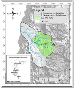
Analysis of Biogeophysics Characteristics and Discharge of Lompo Riaja Atas River and Lompo Riaja Bawah River, Ralla Sub Watershed

Downloads
Downloads
Aeni, N. (2017). Analisis karakteristik biofisik dan debit Sungai Lompo Riaja Atas dan Sungai Lompo Riaja Bawah di Sub DAS Ralla. Universitas Hasanuddin.
Arsyad, S. (2010). Konservasi Tanah dan Air. Bogor: IPB Press.
Asdak, C. (2010). Hidrologi dan PengelolaanDaerah Aliran Sungai. Yogyakarta: Gadjah Mada University Press.
Bach, H., Clausen, T. J., Trang, D. T., Emerton, L., Facon, T., Hofer, T., … Whiting, L. (2011). From Local Watershed Management to Integrated River Basin Management at National and Transboundary Levels.
Basuki, T. M., Adi, R. N., & Sulasmiko, E. (2017). Hasil air hutan jati pada dua sub daerah aliran sungai dengan luas berbeda. Jurnal Penelitian Pengelolaan Daerah Aliran Sungai, 1(1), 1–14.
Calijuri, M. L., Castro, J. S., Costa, L. S., Assemany, P. P., & Alves, J. E. M. (2015). Impact of land use/land cover changes on water quality and hydrological behavior of an agricultural subwatershed. Environ Earth Sci, 74(6), 5373–5382. doi: 10.1007/s12665-015-4550-0.
Hasnawir, Kubota, T., Sanchez-Castillo, L., & Soma, A. D. (2017). The influence of land use and rainfall on shallow landslides in Tanralili sub-watershed, Indonesia.J. Fac. Agr., Kyushu University, 62(1), 171–176.
Hirpa, F. A., Gebremichael, M., & Over, T. M. (2010). River flow fluctuation analysis: Effect of watershed area. Water Resources Research, 46(12), 1–10. https://doi.org/10.1029/2009WR009000.
Isnan, W., & Hasnawir. (2018). Analisis karakteristik dan tipologi DAS Mapili Provinsi Sulawesi Barat.Jurnal Wasian, 5(1), 21–34.
Juanda, D. S. (2016). Deskripsi Karakteristik Biofisik dan Kaitannya dengan Debit Air Sungai Sapaya, Sub DAS Jenelata. Universitas Hasanuddin.
Kementerian Kehutanan. (2013). Peraturan Direktur Jenderal Bina Pengelolaan Daerah Aliran Sungai dan Perhutanan Sosial Nomor: P.3/V-Set/2013 Tentang Pedoman Identifikasi Karakteristik Daerah Aliran Sungai. Jakarta: Biro Hukum Kementerian Kehutanan Republik Indonesia.
Mander, Ü., & Tournebize, J. (2014). Watershed Management☆. Reference Module in Earth Systems and Environmental Sciences, (December 2013), 1–14. https://doi.org/10.1016/B978-0-12-409548-9.09124-7
Mappangaja, B. (1983). The Improvised Current Meter for Stream Discharge Measurement. University of Philipines at Los Banos.
Marwadi, M. (2012). Rekayasa Konservasi Tanah dan Air. Yogyakarta: Bursa Ilmiah.
Mogollón, B., Villamagna, A. M., Frimpong, E. A., & Angermeier, P. L. (2016). Mapping technological and biophysical capacities of watersheds to regulate floods. Ecological Indicators, 61(2016), 483–499. https://doi.org/10.1016/j.ecolind.2015.09.049
Muchtar, A., & Abdullah, N. (2007). Analisis faktor-faktor yang mempengaruhi debit Sungai Mamasa. Jurnal Hutan Dan Masyarakat, 2(1), 174–187.
Nasrullah, & Kartiwa, B. (2009). Model hidrologi DAS Aih Tripe Hulu untukprediksi banjir dan kekeringan. Jurnal Tanah Dan Iklim, 1(29), 35–52.
Ningkeula, E. S. (2015). Analisis karakteristik meteorologi dan morfologi DAS Wai Samal Kecamatan Seram Utara Timur Kobi Kabupaten Maluku Tengah. Jurnal Ilmiah Agribisnis Dan Perikanan, 8(2), 81–91.
Nugroho, P., Marsono, D., Sudira, P., & Suryatmojo, H. (2013). Impact of Land-use Changes on Water Balance. Procedia Environmental Sciences, 17, 256–262. https://doi.org/10.1016/j.proenv.2013.02.036
Nurtaev, B. (2015). Influence of solar activity on global large rivers runoff trends. In Proceedings of the International Association of Hydrological Sciences(pp. 192–193). https://doi.org/10.5194/piahs-366-192-2015
Purwanto, T. H. (2013). Ekstraksi Morfometri Daerah Aliran Sungai dari Data Digital Surface Model (Studi Kasus DAS Opak). Retrieved June 4, 2018, from http://geo.ugm.ac.id/main/?p=2418
Quyen, N. T. N., Liem, N. D., & Loi, N. K. (2014). Effect of land use change on water discharge in Srepok watershed, Central Highland, Viet Nam. International Soil and Water Conservation Research, 2(3), 74–86. https://doi.org/10.1016/S2095-6339(15)30025-3
Rahayu, S., Widodo, R. H., Noordwijk, M. van, Suryadi, I., & Verbist, B. (2009). Monitoring Air Di Daerah Aliran Sungai. Bogor: World agroforestry Centre -Southeast Asia Regional Office. Retrieved from http://www.worldagroforestry.org/downloads/Publications/PDFS/B16396.pdf
Rosyidie, A. (2013). Banjir : Fakta dan dampaknya, serta pengaruh dari perubahan guna lahan. Jurnal Perencanaan Wilayah Dan Kota, 24(3), 241–249.
Sanchez-Castillo, L., Kubota, T., Cantu-Silva, I., Moriyama, T., & Hasnawir. (2017). A probability method of rainfall warning for sediment-related disaster in developing countries: a case study in Sierra Madre Oriental, Mexico.Natural Hazards, 85(3), 1893–1906. http://doi.org/10.1007/s11069-016-2669-2
Soegiyanto. (2014). Pengelolaan Daerah Aliran Sungai Rawan Banjir. Jurnal Geografi, 12(1), 46–58.
Sun, Z., Lotz, T., & Chang, N. Bin. (2017). Assessing the long-term effects of land use changes on runoff patterns and food production in a large lake watershed with policy implications. Journal of Environmental Management, 204, 92–101. https://doi.org/10.1016/j.jenvman.2017.08.043
Supangat, A.B. (2012). Karakteristik hidrologi berdasarkan parameter morfometri DAS di kawasan Taman Nasional Meru Betiri.Jurnal Penelitian Hutan dan konservasi Alam, 9(3), 275–283.
Wahyuni. (2012). Karakteristik Debit Sungai Pada DAS Tallo Hulu (Sub DAS Jenepangkalung Dan Sub DAS Jenetalinggoa). Universitas Hasanuddin.


