ANTICIPATING THE IMPACT OF SEA LEVEL RISE AND ITS MITIGATION IN THE GALESONG TAKALAR COASTAL AREA
DOI:
https://doi.org/10.62012/sensistek.v7i1.31671Keywords:
Human Activity, Takalar Regency, Disaster, BeachAbstract
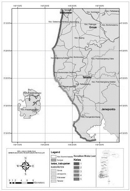
Indonesia is an archipelago, and some cities began as coastal towns. Takalar, a coastal city, has experienced social, cultural, and economic development. The Galesong Coastal Area, located in Takalar Regency, South Sulawesi, has various aspects of social, cultural, and financial life, as well as a tourism sector. The relative sea level on the Galesong coast ranges between 6,203 and 6,274 mm per year. On the other hand, sea level rise has tremendous effects on climate change and marine disasters. Some of the effects produced by sea level rise include increased frequency and intensity of flooding, changes in ocean currents, greater mangrove damage, and increased threats to the socioeconomic activities of coastal communities. The purpose of this study is to identify the effects and sources of sea level rise and disasters, hence this study shows the impacts on coastal communities and surrounding marine ecosystems. Based on the declining terrain, socialisation and education of the community on disaster mitigation, and the creation of evacuation routes are some of the impacts that can be anticipated from sea level rise and disasters.Downloads
References
Syahrir, W. E., Sakka, & Arif, Samsu., (2014), Analisis Kerentanan Pantai Di Kabupaten Takalar, Program Studi Geofisika Jurusan Fisika, Fakultas Matematika dan Ilmu Pengetahuan Alam, Universitas Hasanuddin.
Hidayat, A. (2015). Analisis Pengembangan Kawasan Pesisir Berbasis Mitigasi Sea Level Rise (Kenaikan Muka Air Laut) Studi Kasus Kawasan Kota Lama Makassar. Jurnal Lingkungan Binaan Indonesia, 1(1), 87–100.
Risnawati, (2021), Arahan Pemanfaatan Lahan Di Pesisir Pantai Galesong Utara Kabupaten Takalar, Jurusan Teknik PWK Fakultas Sains dan Teknologi UIN Alauddin Makassar.
Sakka, Muzaki A A, (2010). Modul Pelatihan Pembangunan Indeks Kerentanan Pantai Pengolahan Data Geomorfologi Pantai.
Liyani, Sambodho K, dan Suntoyo, Analisa Perubahan Garis Pantai Akibat Kenaikan Muka Air Laut di Kawasan Pesisir Kabupaten Tuban, Teknik Kelautan, Fakultas Teknologi Kelautan, Institut Teknologi Sepuluh Nopember (ITS)
Klein RJT & Nicholls RJ. 1999. Assesment of coastal vulnerability to climate change. Ambio, 28(2). 182-187.
Prasetyo, A. F., Rachman T., Paotonan C., 2020, Identifikasi Kerusakan Pantai Kawasan Pesisir Kecamatan Galesong Utara, Kabupaten Takalar, Sulawesi Selatan, Departemen Teknik Kelautan Universitas Hasanuddin
Teuku M., (2020). Abrasi di Galesong, Sulsel, Makin Parah, Tanggul Penahan Ombak Hancur. Diakses pada 31 oktober 2022 dari https://regional.kompas.com/read/2020/02/04/01211531/abrasi-di-galesong-sulsel-makin-parah-tanggul-penahan-ombak-hancur?page=all
Tim SINDOnews. (2020). Wagub Sulsel Tanam Mangrove di Pesisir Pantai Takalar. Diakses pada 25 Oktober 2023 dari https://daerah.sindonews.com/read/89830/713/wagub-sulsel-tanam-mangrove-di-pesisir-pantai-takalar-1593785250
Kabar Nusantara News. (2022). BLH PP Sulsel Gotong Royong Tanam Mangrove di Pantai Galesong. Diakses pada 31 Oktober 2022 dari https://kabarnusantaranews.com/blh-pp-sulsel-gotong-royong-tanam-mangrove-di-pantai-galesong/
Antarafoto. (2023). MEMBUAT TANGGUL SEMENTARA CEGAH ABRASI PANTAI DI TAKALAR. Diakses pada 25 Oktober 2023 dari https://www.antarafoto.com/id/view/1853730/membuat-tanggul-sementara-cegah-abrasi-pantai-di-takalar


